Tropical Storm Chantal forms in Atlantic
Published 8:39 am Monday, July 8, 2013
- 115019W5_NL_sm.jpg
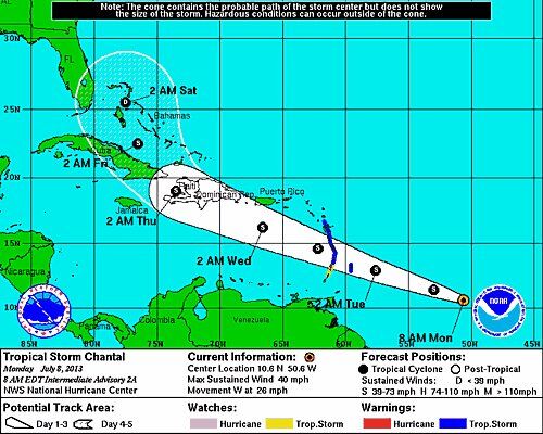
Tropical Storm Chantal formed late Sunday night and is moving quickly toward the Lesser Antilles with maximum sustained winds at 40 mph.
Trending
If Chantal remains on the present projected path, she could make landfall in South Florida sometime Saturday.
Tropical storm warnings are in effect for Barbados, Dominica adn others.
At 8 a.m. today, Chantal was moving toward the west near 26 mph and a west-northwestward motion at about the same forward speed is expected over the next couple of days.
On the forecast track, the center of Chantal should reach the Lesser Antilles early Tuesday and move into the Eastern Caribbean Sea later on Tuesday.
Maximum sustained winds remain near 40 mph with higher gusts. Some increase in strength is forecast during the next 48 hours.
Tropical storm force winds extend outward up to 60 miles from the center.
Trending
Chantal is expected to produce rain accumulating of two to four inches over the Leeward and Windward Islands, with maximum amounts of six inches possible.
The next advisory will be around 11 a.m. Keep current here at suwanneedemocrat.com.